


Maps and Driving Directions
Thanks to online maps, there's no excuse for getting lost on the Internet. These excellent online mapping tools will get you from one place to another, and some are interactive. The new breed of online maps are aware of businesses, attractions, topography, and even traffic conditions along the way. Other online maps combine geography with fun, learning and social networking. Check out some of the best new online mapping tools here... |
Mapquest and Other Online Maps
We've come a long way since the days of those frustrating fold-out maps and bulky road atlas books. Here are some of my favorite online mapping tools, and some very cool "mashups" that combine mapping tools with other web services.
- Mapquest is an online map service that's been helping people find their way since 1996. Every month, 40 million people use MapQuest, which ranked as the #1 mapping site. To start, just put in as much information as you know. For example, you can just enter "restaurants" and the city. Mapquest will take it from there and provide you with a list of nearby "hits" along with links to an area map and driving directions. Of course you can also enter a specific address, intersection, city name or zipcode. Mapquest maps are interactive, so you can zoom in/out, or click and drag the map in any direction.
- Yahoo Maps can also take you just about anywhere you need to go. Once nice feature of Yahoo Maps is that when you first call up the site, it displays a map of your local area, based on your IP address. You can also see Live Traffic reports that alert you to congestion, lane closures and construction delays. I was pleasantly surprised to find the traffic data was very current -- one report of a lane closure on a highway near me was posted only minutes ago.
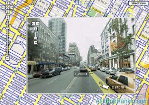
- Google Maps is my favorite online mapping tool. In addition to maps and driving directions, they offer detailed hybrid views combining road maps with satellite imagery. Some other sites offer the satellite images, but in my experience the quality and detail is far better with Google Maps. Even cooler is the Street View option, which gives you a panoramic view of city streets and highways. You can turn and look in any direction, even simulate a walk or drive down the street. When you arrive, it'll feel like deja vu all over again! I also like the interactive route manipulation feature, which lets you drag the proposed route to avoid or include a specific point, road or town.
Some people complain that the automated turn-by-turn directions offered by the online mapping services are not always the best or fastest route, so I recommend that you check more than one if you're not familiar with the area you travelling through.
Maps and Mashups
Mashups are a combination of two web services that work together to create a new service. For example, in cooperation with Google, it is now possible to search for real estate online at CraigsList. You select the area and suggest housing at any price you can afford. The options are almost limitless whether you want to purchase, rent, or sublet.
Google also teamed up with the U.S. Holocaust Memorial Museum to draw attention to the crisis in Darfur. Over 2.5 million of its inhabitants have been killed and over 200,000 displaced. Crisis in Darfur is the first part of a project designed to allow citizens, governments, and outside sources to see what is actually occurring in potential genocide situations. Tent icons mark the refugee camps and flaming icons display villages that have been destroyed.
National Geographic's Map Machine allows you to click on an area and study it without having to leave your computer. You can discover specific countries or worldwide trends in terms of population, climate control, and much more. We again looked at the Gulf Coast and were able to track hurricanes and their paths.
- WeatherBonk is a mashup of Google Maps and a collection of weather services.
- MiBazaar combines Google Maps, Google News, Yahoo Geocoding, and Yahoo Local to show you local news, photos and restaurants.
- Flickr Maps is a mashup of Yahoo Maps and Flickr. Choose a city across the USA, and view associated photos from Flickr.
- I am Caltrain uses Yahoo Maps, Caltrain schedules and Flickr Photos to help you plan your rail travel in California. Find out which train stops have amenities like bike lockers and parking as well as when the next train will arrive.
- Flight Tracker will track the flights bound for major cities.
- New York City Taxi Fare Finder will calculate the cost of a cab ride from one point in NYC to another. Just in case you were wondering it'll cost about $12.51 to travel the 4.1 miles by cab from Grand Central Station to the South Street Ferry.
You'll love Google Earth, which offers a close-up view of almost any place on the planet, including your own neighborhood. Enter your home address, and watch it zoom in to that spot from outer space. You can pan, zoom and tilt to see the ground from various perspectives. Explore points all over the world. Or try the hidden "flight simulator" feature, activated by pressing Ctrl-Alt-A. Search for "Google Earth easter eggs" on Google for other fun stuff you can do or find. When you're done exploring this planet, try Google Sky to fly through space, explore strange new worlds, seek out new life and new civilizations.
If you're building a website and would like to create your own maps mashup, there are APIs (application programming interfaces) from which to choose. Both the Yahoo and Google maps websites have information on what you need to incorporate one into your site. Do you have a favorite maps service or mashup? Share it with us below...
|
|
|
This article was posted by Bob Rankin on 22 Oct 2007
| For Fun: Buy Bob a Snickers. |
|
Prev Article: HP OfficeJet Pro L7780 |
The Top Twenty |
Next Article: New Power Supply |
Post your Comments, Questions or Suggestions
|
Free Tech Support -- Ask Bob Rankin Subscribe to AskBobRankin Updates: Free Newsletter Copyright © 2005 - Bob Rankin - All Rights Reserved About Us Privacy Policy RSS/XML |
Article information: AskBobRankin -- Maps and Driving Directions (Posted: 22 Oct 2007)
Source: https://askbobrankin.com/maps_and_driving_directions.html
Copyright © 2005 - Bob Rankin - All Rights Reserved
Most recent comments on "Maps and Driving Directions"
Posted by:

Wayne
23 Oct 2007
A great mapping tool for driving trips is available from your old friend AAA at no cost. Take a look at the tool at http://www.autoclubgroup.com/chicago/travel/aaa_maps_landing.asp
Posted by:

Chris
24 Oct 2007
An additional feature of Google Maps that I absolutely love is the ability to override the directions Google wishes you to take and create a map with turn-by-turn directions using the roads you want to take (or perhaps more often avoiding the roads you wish to avoid).
Posted by:

Al
24 Oct 2007
Is there anything that can be done to correct an erroneous address? Yahoo, Mapquest and Expedia locate my home address a mile west of where I actually live. Google puts me 3 miles east of my location. The street I actually live on shows up on all maps; my house is visible on the satellite photos; I live in town. Why is this such a problem?
EDITOR'S NOTE: Google Maps has a contact link: http://maps.google.com/support/bin/request.py
Posted by:

Raphael
25 Jul 2008
I'm taking a bicycle trip to Southwest China (Yunnan and Sichuan provinces) and I was wondering if there is any kind of a mashup that allows me to create a road atlas or gazeteer. Something that will enable me to print (at a state and local highway level) the whole province but tag each map to a province-map (i.e. with grid lines and numbers over the province map).
It seems that there are so many helpful mashups out there but nothing that allows a person to use google or yahoo maps to create a detailed, systematic set of maps for a whole area.
Any ideas?
Posted by:

Destin Beach Weddings
20 Dec 2008
I love the google maps they helped me find my location for my Destin Beach Wedding this last spring.
Posted by:

Candice
29 Dec 2008
I'm trying to copy and paste in mapquest or google maps to be able to print a map and directions for a wedding. Do you know if you can do that?
EDITOR'S NOTE: I think the best way would be to do a screen capture. See http://askbobrankin.com/take_a_screenshot.html
Posted by:

Clare
26 Jan 2009
Hello does anybody have a suggestion of what i can use, to put in a mutiple of addresses, to access in one day, that a site can offer the best route to achieve this, Cheers Clare